The Green Mountain Railway, Acadia National Park
2021 is the year the National Park Service began limiting the amount of traffic to the top of Cadillac Mountain in Acadia National Park through a reservation system. While change is hard, the experience at the summit is far better than previous years. But there was a day when the only way to the top was hike, buckboard wagon, or for a short time, a cog railroad.
Let’s travel back in time to around 1883, before Acadia National Park existed. A Bangor, Maine entrepreneur, Frank Clergue, conceived an idea to build a cog railroad up the west face of Green Mountain (renamed Cadillac in 1918). He knew of the success of the Mount Washington, New Hampshire cog railroad that had been operational since 1869.

Source: Bangor Public Library. https://digicom.bpl.lib.me.us/railroad_other_img/2/
Mr. Clergue rounded up financial backing from prominent Bangor businessmen, and kept the plan relatively quiet from Bar Harbor residents but fully complied with Maine’s railroad laws. His first major public announcement to the Bar Harbor community was an ad placed in the Mount Desert Herald on January 18, 1883 soliciting proposals for all aspects of building the railroad. The local sentiment was not in favor of this enterprise, but little could be done to stop it by then.

Source: Bangor Public Library. https://digicom.bpl.lib.me.us/railroad_other_img/1/
Work on the railroad started February 19, 1883 and the grand opening celebration was held June 23, 1883, just over four months after construction began. Remarkable progress in a very short time.
In addition to the railway, Clergue’s operation included transport by buckboard wagon from Bar Harbor to Eagle Lake; a steamship, the Wauwinet, for transportation on Eagle Lake to the railway base station; and the three-story, 16-room Green Mountain House at the mountain summit.

Green Mountain House, ca. 1883. Source: Southwest Harbor Public Library. https://swhplibrary.net/digitalarchive/items/show/12360
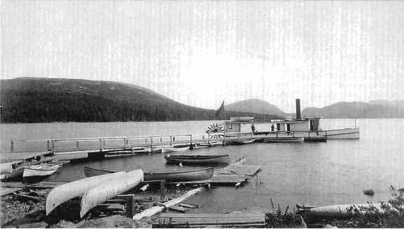
The Wauwinet, at the North Eagle Lake wharf, ca. 1884. The rail terminal lies out of sight, just beyond the point of land left of the smokestack. Source: History of the Bar Harbor Water Company, 1873-2004. http://me-barharbor.civicplus.com/DocumentCenter/View/133/A-History-of-Bar-Harbor?bidId=

An early photo of the Green Mountain Railway base station at the shore of Eagle Lake, probably 1883. The two locomotives ran in series on one track depending on the number of passengers. There was no way for the engines to pass each other. Mount Desert Views, Forbes Co., 1890. https://digitalcommons.library.umaine.edu/cgi/viewcontent.cgi?article=1070&context=mainehistory
Unfortunately, the Green Mountain Railway was only operational for seven years. Ridership had declined by 1890 to the point that the operation was abandoned in 1891. A sale of equipment was held by the Hancock County Sheriff’s office in 1893, and the two locomotives were eventually purchased by the Mount Washington Railway in 1895.
By 1897, all but one of the steel rails were removed from the mountain and recycled. The timber used for support, ties and cribbing was discarded to the side of the railbed and left to rot.
Fast forward to present day.
The remains of the cog railway, while hidden and unmarked, still exist in Acadia National Park. I found out about the story and remnants in 2020, and set a goal in 2021 to track and record the entire route up the west face of Cadillac Mountain. This was accomplished in September 2021 when a good friend and I set out to find the complete path.
The entire path is mostly bushwacking with little more than a deer trail at best. It is overgrown and impassible in places with at least 70 years or more of forest growth. While many have hiked this path, or portions of it, for the last 140 years or so, as far as I know this is the only GPS track of the path that exists.

GPS Track of the Green Mountain Railway, September 2021.
My friend did the detail work and overlayed the GPS path with old maps that show the Green Mountain Railway, and found some very interesting results. Turns out the old mapmakers, while they created beautiful works of art, were only as accurate as their technology and detail allowed.

GPS track overlay of 1887 map published by Colby & Stuart. Library of Congress location http://hdl.loc.gov/loc.gmd/g3732m.np000025

Colby & Stuart map of Eden, Mount Desert, Tremont and the Cranberry Isles for F.D. Foster, 1887. http://www.old-maps.com/blog/wp-content/gallery/mtdesertisland/MtDesert_1887_Colby_web.jpg

Topographic map of Acadia National Park, US Department of the Interior Geological Survey, 1960. http://hdl.loc.gov/loc.gmd/g3732a.np000042
What remains of the Green Mountain Railway are hundreds of iron pins embedded in granite - usually in sets of three abreast but frequently with only one or two remaining; granite cribbing used to support the railbed; piles of various discarded chisels, spikes, and worn drill bits; and one lone remaining rail.
That makes me wonder if those workers in 1897 intentionally left one rail for others to discover that would provide testimony to the engineering marvel that once existed.


The lone remaining rail section, located between the Park Loop Road and the Cadillac Summit Road, September 2021.

Remaining pins of the Green Mountain Railway at the start of the upper section, just above the first crossing of the Cadillac Summit Road, September 2021.

The last remaining pin, located approximately 50 feet east northeast of the Cadillac Mountain Summit benchmark. The pin is sawed off flush with the granite. September 2021.

The summit benchmark for Cadillac Mountain, 1,530 feet above sea level.
The two locomotives were sold to the Mount Washington Cog Railway in 1895.
Engine #1, named Mt. Desert, was renamed MWCR #4 Summit. It was renamed Chocorua in 1999 and renamed again #8 Moosilauke in 2009 when it was retired from service. The Mt. Desert/Chocorua/Moosilauke was donated to the village of Carroll, New Hampshire in 2018 where it sits on display at the intersection of US Highway 3 and US Highway 302.
Engine #2 was never named by Green Mountain Railway. It became #3 Base Station, and renamed Agiocochook in 1995-96. It was last operational in 2009, but is still stored and serviceable with the Mount Washington Cog Railway.


Engine #1, the Mount Desert, renamed Moosilauke, sits on permanent display in Carroll, New Hampshire, as a tribute to the Mount Washington Cog Railway. https://lccn.loc.gov/2017884973
The Summit House was dismantled in 1896, and the remaining skeletal structure was burned the same year.
The Wauwinet steamship was sunk in Eagle Lake in about 100 feet of water. There is a record of divers searching the wreckage in 2007, and a 2015 historical view of Google Earth clearly shows what appears to be the sunken wharf and a hull-shaped object at the north end of Eagle Lake..

July 2015 view from Google Earth shows the appearance of a sunken wharf and an object near the north shore of Eagle Lake, where the ferry landing was.
A very special thanks to my anonymous friend, who was excited to accompany me in the discovery expeditions, and to Peter Dow Bachelder for his outstanding work documenting the history and details of the Green Mountain Railway, Steam to the Summit, Breakwater Press, 2005. His book is a “must-have” for anyone interested in the history of this fading treasure of Acadia National Park.
If you’re interested in the path:
Easiest access: Park Loop Road, second turnout south of the intersection with Cadillac Mountain Summit Road. Downhill, look for a cut granite stone that looks like it could be a railroad tie. It’s not, but that is the rail bed and you’ll find an iron pin in the ground just below it. Uphill, cross the road and scramble up the embankment and follow a rough trail slightly to the left. There are exposed iron pins within about 20 feet.
From the shore of Eagle Lake to the carriage road, the location of the railway terminus and wharf is unrecognizable. Recent carriage road improvements and drainage construction have flooded the area and created a swamp, with no observable outlet to Eagle Lake. The built-up bank on the shore was, in all likelihood, support for the wharf.
East of the Eagle Lake carriage road, the flat location of the lower railway terminal is evident There are remains of rock foundations and bricks, probably the terminal, the work station and maintenance shed. Further east a significant creek crossing exists with a ledge waterfall just to the left, and on the east side of the creek bank the embedded iron pins begin to show up. The railway bed is clear and obvious from that point eastbound and uphill until the Park Loop Road.
The path crosses the Park Loop Road at the second turnout south of the Cadillac Summit Road/Park Loop Road intersection.
The rail bed pins can be tracked almost the entire way between the Park Loop Road and the Cadillac Summit Road.
The path crosses the Cadillac Summit Road at a drainage culvert uphill (south) of the Bar Harbor/Porcupine Island overlook and after a semi-straight section of the road.
Between the first crossing of the Summit Road and the second, I was only able to find pins about half way up before losing the railway bed due to extensive overgrowth. Further exploration might uncover the bed, but this is a very dense and overgrown section of forest and easily disorienting.
The junction of the railway path and the second crossing of the Summit Road is completely destroyed by road construction on the downhill (north) side. The uphill ledge and path that continues to the summit is quite visible, approximately 150 feet west of the crosswalk leading to the Summit Gift Store.
A few pins remain in the railway bed between the Summit Road and the fenced area of the communication tower. The remaining portion of the rail bed has been disrupted due to a generator fuel tank, hidden from the public’s eye. There is only one remaining sawed-off pin at the summit, about 50 feet east northeast of the summit benchmark.